Angura Poster vs Hatsusaburō Panoramic Map
アングラ演劇ポスター / 初三郎式鳥瞰図
Angura Poster comes from Regional Graphics and Hatsusaburō Panoramic Map from Diagrammatic Expression. They are reached for with some of the same intent, which is where they get confused.
Angura Poster
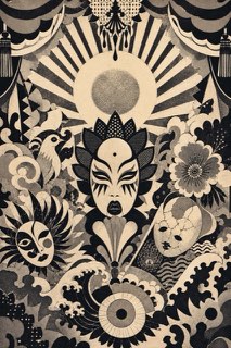
Yokoo Tadanori and his peers printed the posters for Situation Theatre and Tenjō Sajiki. Ukiyo-e, kitsch and psychedelia collide there in an excess that the world discovered as a revolt against modernism.
Hatsusaburō Panoramic Map


The tourist bird's-eye map style perfected by Hatsusaburō Yoshida: extravagantly curved horizons, exaggerated landmarks and a view that pulls distant cities into one sheet, turning Taishō and Shōwa era travel into pictorial maps.
| Angura Poster | Hatsusaburō Panoramic Map | |
|---|---|---|
| Era | 1965–1975 | 1913–1950s |
| Family | Regional Graphics | Diagrammatic Expression |
| Kind | Style | Style |
| Cues | Ukiyo-e colliding with kitsch / Fluorescent silkscreen / Rising suns and Shōwa imagery détourned / The aesthetics of excess | Curving horizons / Exaggerated landmarks / Extreme wide-angle views / Painterly color |
| Best used for | Small-theatre and experimental performance bills that must defy respectable style · Work quoting Showa-era imagery and stopping a passerby through sheer excess | Conveying a destination's whole layout and access in one enjoyable sheet · Placing distant landmarks on one view by ignoring real distance |
| Type | Mincho, sign lettering and Latin colliding on one surface, alignment broken on purpose | Vertical brush lettering for place names, larger for the famous ones |
| Composition | One image at the center, the surround packed with detail and no white left | Curve the horizon strongly and stretch the featured area toward the viewer |
| Material | Silkscreen including fluorescents, with metallics and spot colors overlaid | Pale watercolor ground with shrine vermilion and mountain green printed over |
| Caution | Merely piling quotations turns excess into clutter and buries the title and dates the bill exists to announce. | Pushing curve and exaggeration until the order of the route breaks gives a map that is fun to look at and useless on the ground. |